


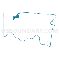
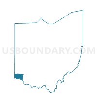
Voting District CROSBY A, Hamilton County, Ohio
About
Outline

Summary
| Unique Area Identifier | 647643 |
| Name | Voting District CROSBY A |
| County | Hamilton County |
| State | Ohio |
| Area (square miles) | 5.15 |
| Land Area (square miles) | 4.77 |
| Water Area (square miles) | 0.37 |
| % of Land Area | 92.72 |
| % of Water Area | 7.28 |
| Latitude of the Internal Point | 39.27661490 |
| Longtitude of the Internal Point | -84.67060350 |
Maps

Graphs
Select a template below for downloading or customizing gragh for Voting District CROSBY A, Hamilton County, Ohio


Neighbors
Neighoring Voting District (by Name) Neighboring Voting District on the Map
- Voting District COLERAIN A, Hamilton County, OH
- Voting District COLERAIN F, Hamilton County, OH
- Voting District COLERAIN VV, Hamilton County, OH
- Voting District CROSBY B, Hamilton County, OH
- FAIRFIELD TWP FFTWP14 Voting District, Butler County, OH
- ROSS TWP ROSS2 Voting District, Butler County, OH
- ROSS TWP ROSS6 Voting District, Butler County, OH
- Voting District WHITEWATER B, Hamilton County, OH
- Voting District WHITEWATER C, Hamilton County, OH
Top 10 Neighboring County Subdivision (by Population) Neighboring County Subdivision on the Map
- Colerain township, Hamilton County, OH (58,499)
- Fairfield township, Butler County, OH (21,373)
- Ross township, Butler County, OH (8,355)
- Whitewater township, Hamilton County, OH (5,519)
- Crosby township, Hamilton County, OH (2,767)
Top 10 Neighboring Place (by Population) Neighboring Place on the Map
- Ross CDP, OH (3,417)
- Taylor Creek CDP, OH (3,062)
- Dry Ridge CDP, OH (2,782)
- Dunlap CDP, OH (1,719)
- New Baltimore CDP, OH (661)
Top 10 Neighboring Unified School District (by Population) Neighboring Unified School District on the Map
- Northwest Local School District, OH (74,442)
- Southwest Local School District, OH (22,728)
- Ross Local School District, OH (16,018)
Top 10 Neighboring State Legislative District Lower Chamber (by Population) Neighboring State Legislative District Lower Chamber on the Map
- State House District 30, OH (114,509)
- State House District 54, OH (114,483)
- State House District 29, OH (113,937)
Top 10 Neighboring State Legislative District Upper Chamber (by Population) Neighboring State Legislative District Upper Chamber on the Map
Top 10 Neighboring 111th Congressional District (by Population) Neighboring 111th Congressional District on the Map
Top 10 Neighboring Census Tract (by Population) Neighboring Census Tract on the Map
- Census Tract 108, Butler County, OH (6,568)
- Census Tract 205.02, Hamilton County, OH (4,763)
- Census Tract 260.02, Hamilton County, OH (4,740)
- Census Tract 109.11, Butler County, OH (4,226)
- Census Tract 205.01, Hamilton County, OH (2,146)